Guilin's karst is one of the world's great humid subtropical tower-karst landscapes: a geological archive, a biodiversity mosaic, and the visual template for centuries of Chinese shanshui imagination.
At a glance
Key takeaways
- Karst landscapes form when soluble rocks are gradually dissolved by mildly acidic water over long periods of time, and Guilin is one of the world's finest examples.
- Guilin's karst took shape through three major stages: ancient shallow-sea sedimentation, tectonic uplift, and long-term sculpting by flowing water over roughly 300 million years.
- The defining features of karst landscapes include peak forests, caves, underground rivers, natural bridges, and sinkholes — all of which are found in Guilin in exceptional variety and beauty.
- Guilin karst combines four outstanding values: world-class natural heritage, the cultural legacy of Chinese landscape aesthetics, ecological and scientific importance, and a long history of coexistence between people and nature.
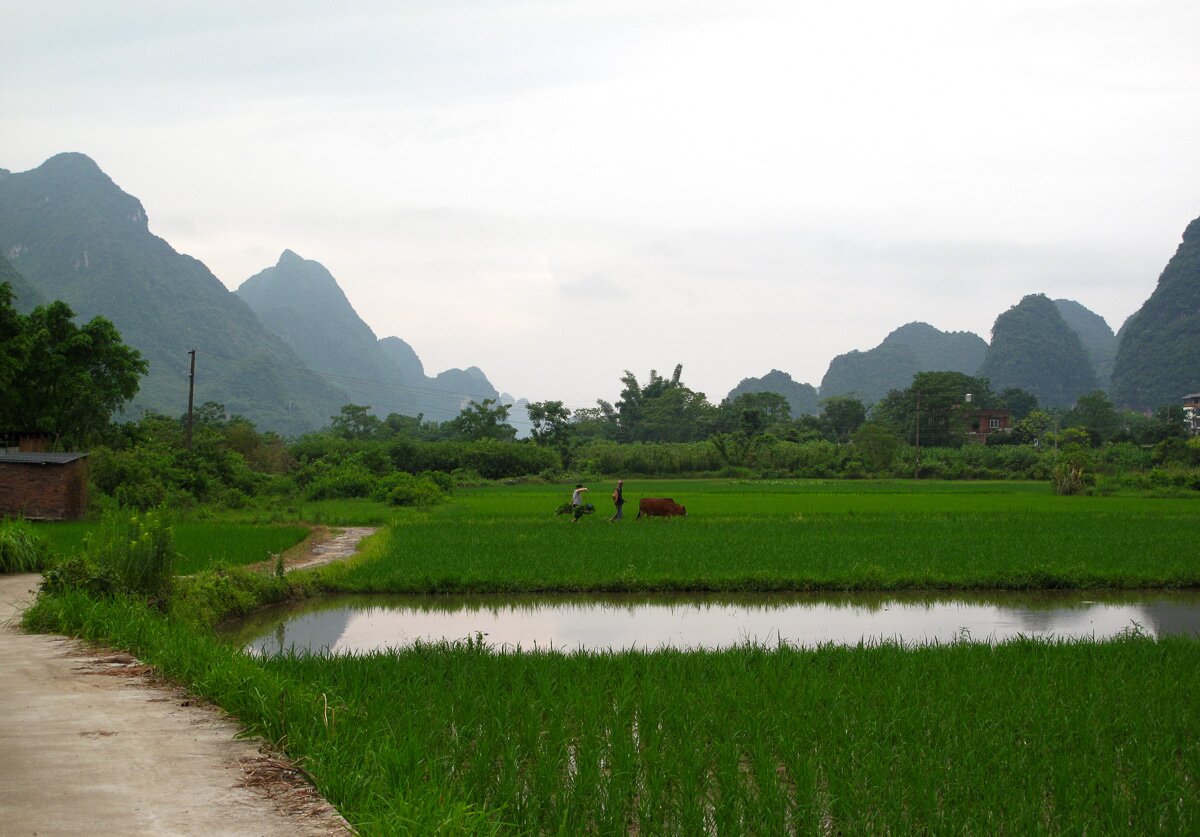
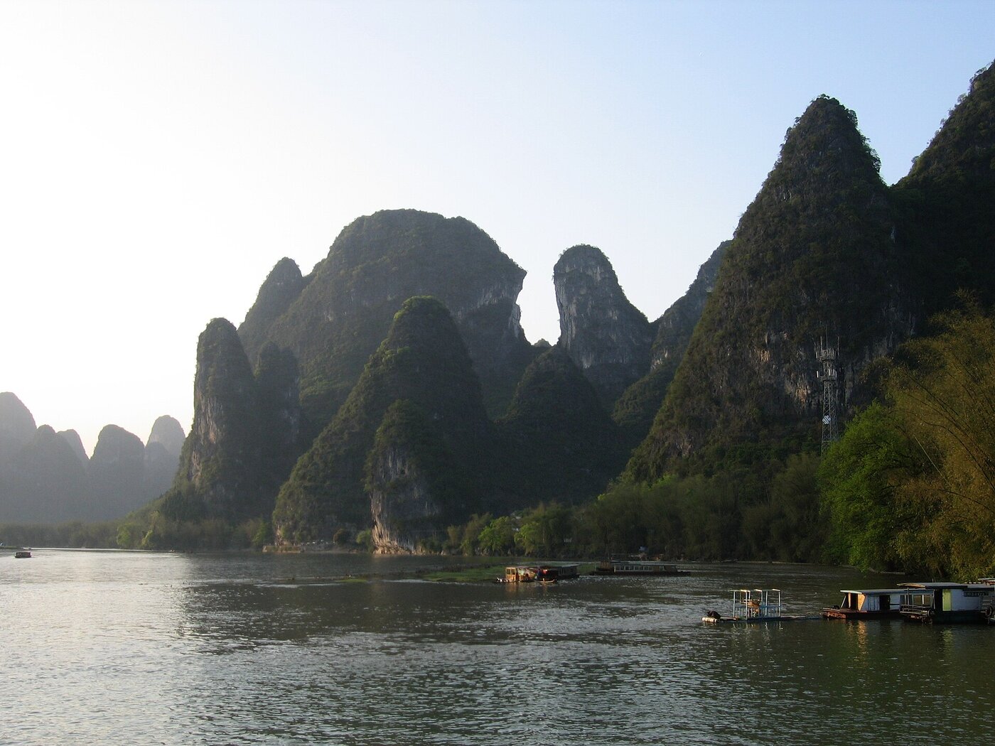
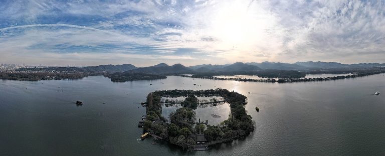
Guilin's karst landscape has created one of the most poetic natural scenes on Earth. Picture yourself drifting down the Li River on a slow boat. Around you, green limestone peaks rise straight from the ground — not as part of a continuous mountain range, but like giant bamboo shoots growing out of the earth. Their reflections shimmer on the water. Water buffalo graze quietly along the riverbanks. A fisherman in a bamboo hat stands on a bamboo raft. For many Chinese people, this is the very image of shanshui — the timeless ideal of "mountains and waters."
As a core area of the South China Karst UNESCO World Natural Heritage Site, Guilin is widely regarded as one of the world's finest examples of tropical and subtropical tower karst. It is also one of the top destinations in China for international travelers who want to explore karst landscapes firsthand.
For visitors, Guilin karst is far more than a famous scenic backdrop. It is a living record of geological evolution, a source of inspiration for traditional Chinese landscape painting, and a homeland where ethnic communities such as the Zhuang have lived for generations. To travel through Guilin is to experience not only the extraordinary power of nature, but also the deep cultural traditions that have grown alongside it.
Part 1 自然史 · 喀斯特
What is a karst landscape? A 300-million-year story of water sculpting stone
The term "karst" comes from the Kras region of Slovenia. Today, geologists use it to describe landscapes shaped by the dissolution of soluble rocks, especially limestone. Put simply, karst landscapes are created when water slowly carves its way through stone.
Limestone is mainly made of calcium carbonate. It may look strong and permanent, but it slowly dissolves when exposed to mildly acidic water. Over millions of years, this quiet process transforms solid rock into caves, underground rivers, sinkholes, and the dramatic limestone peaks that define Guilin's scenery.
Guilin's geological story
Around 300 million years ago, during the Devonian to Permian periods, the area that is now Guilin lay beneath a warm, shallow sea. As marine organisms such as corals, shellfish, and algae died, their calcium-rich remains accumulated on the seafloor, layer by layer. Over time, these deposits were compressed into exceptionally pure limestone beds more than 3,000 meters thick, creating the geological foundation for Guilin's future karst landscape.
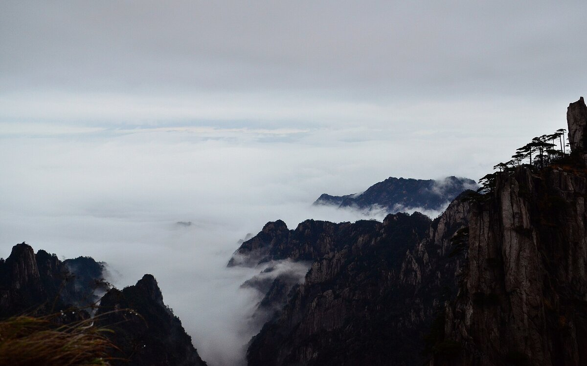
Later tectonic uplift raised these ancient seabed layers above sea level, turning them into a broad limestone plateau exposed to rain, rivers, and weathering. Over the millions of years that followed, Guilin's warm, humid subtropical climate became the master sculptor of the landscape. Slightly acidic rainwater seeped into cracks in the rock and slowly dissolved the limestone. Vertically, this process cut the plateau into isolated peak forests. Horizontally, it hollowed out the mountains to form extensive cave systems. As some cave roofs collapsed, the surface landscape evolved further, giving rise to dramatic sinkholes and natural bridges.
This long geological sequence — from ancient sea to limestone plateau to peak-filled karst landscape — gradually transformed a mass of pale rock into the spectacular natural maze of mountains and waterways that defines Guilin today.
Part 2 地貌 · 峰林溶洞
Karst landscapes at their best: peak forests, caves, and sinkholes
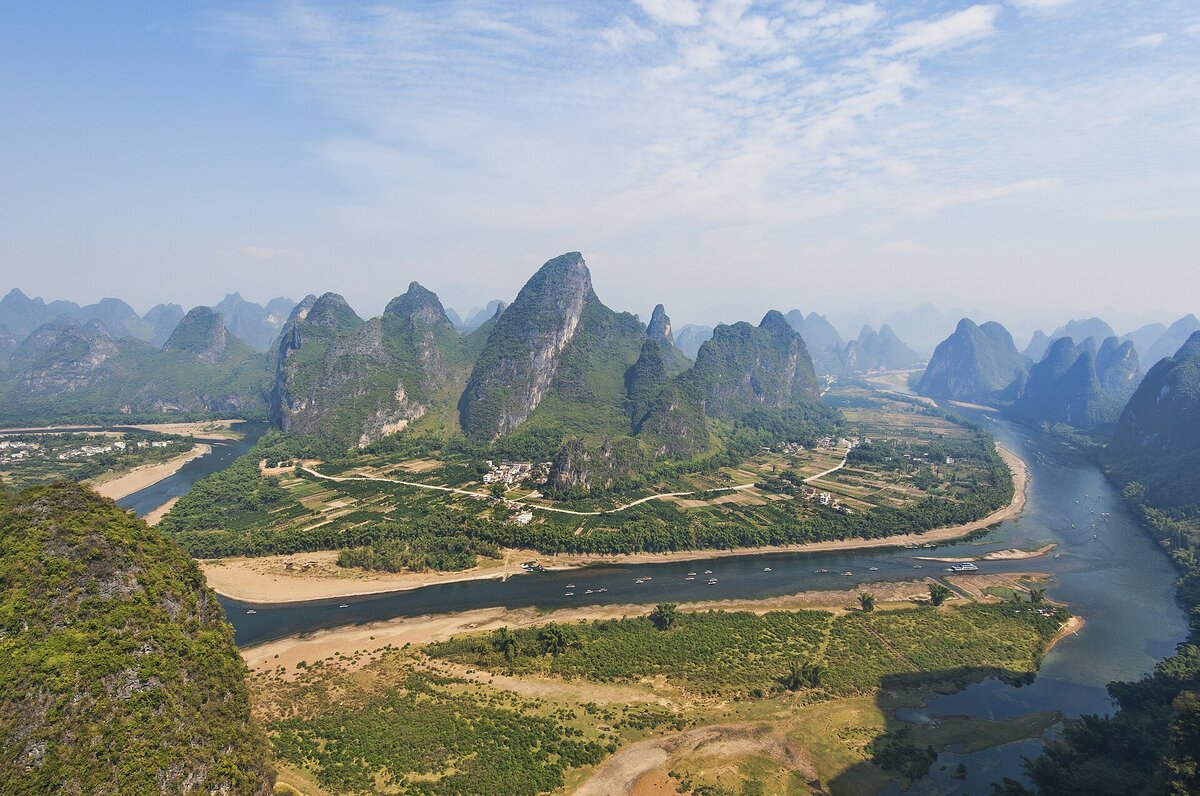
Guilin is one of the most complete karst landscape regions in the world. Among its many landforms, the most representative — and the most visually striking — are its peak forests, caves, and underground rivers.
Peak forests and peak clusters
Peak forests mark a mature stage in karst development and are the defining feature of Guilin's landscape. These limestone peaks stand apart from one another, rising abruptly from the plains in rounded, bamboo-shoot-like forms and spreading gracefully between rivers and open land. Peak clusters, by contrast, can be seen as an earlier stage of the same process: their bases remain connected, and the peaks gather closely together in dense, dramatic formations.
| Landscape / site | Core experience |
|---|---|
| Essential Li River route (Guilin to Yangshuo) | Boat downstream through classic Li River scenery — a moving scroll of mountains and water, with highlights such as the Yellow Cloth Shoal reflection in Xingping and Nine Horse Fresco Hill. |
| Yangshuo Ten-Mile Gallery | Cycle or walk through countryside that feels like moving through a traditional Chinese landscape painting. |
| Putao Peak Forest, Yangshuo | One of the world's largest and best-preserved peak-forest landscapes, often praised by geologists as a crown jewel of karst peak forests. |
| Xianggong Mountain | One of the best viewpoints for sunrise over the first great bend of the Li River. |
Karst caves: nature's underground palaces
When calcium-rich groundwater seeps into karst caves, droplets hanging from the ceiling either evaporate or release carbon dioxide. As a result, the dissolved calcium carbonate is deposited again. Each drop leaves behind a tiny mineral ring. Over tens of thousands — or even hundreds of thousands — of years, these deposits gradually build downward from the ceiling as stalactites and upward from the floor as stalagmites. When the two finally meet, they form towering stone columns.
Guilin's caves are famous for their large number, striking formations, and excellent preservation. In fact, it often seems that nearly every mountain has a cave of its own.
| Cave | Highlights |
|---|---|
| Reed Flute Cave | Stone curtains, stalagmites, and columns in many forms; delicate formations and easy walking paths — nicknamed the "Palace of Natural Art." |
| Silver Cave | Bright, crystal-like stalactites that appear to sparkle like silver under lights; among the most impressive cave sights in the Guilin area. |
| Crown Cave | Large cave system connected with an underground river; dramatic stalactites and spacious chambers — classic underground karst scenery. |
Underground rivers and natural bridges
Beneath Guilin lies a hidden world that is every bit as remarkable as the landscape above ground. A network of underground rivers runs through the karst terrain and forms an important part of the Li River basin's water system. When part of a cave roof collapses, it can create a skylight that opens to the surface, allowing sunlight to reach the dark river below. If a curved section of rock remains spanning the water, it forms a natural bridge.
| Site | Landscape features |
|---|---|
| Crown Cave underground river | One of Asia's longest underground rivers open to visitors, with waterfalls and unusual stalactite formations. |
| Chuanshan Moon Cave | Among Guilin's traditional "Eight Scenic Wonders" — a round opening resembling a full moon against the Li River landscape. |
| Huixian Karst Wetland | One of China's largest karst wetlands — lakes and marshes surrounded by peak forests; important ecological buffer for the Li basin. |
Part 3 生态 · 人文
Life and civilization in karst: the ecological code of the landscape
Guilin's karst landscape is more than a collection of peaks and caves. It is also a place where life has adapted to difficult conditions, and where human communities have developed practical ways to live with the land.
The region supports hidden pockets of biodiversity, while its farming systems and traditional buildings show how people have responded to steep slopes, thin soils, and complex water systems. In Guilin, nature and culture are not separate stories. They are part of the same long process of adaptation.
A hidden biodiversity hotspot
Karst landscapes support a surprisingly rich range of habitats. In Guilin, steep limestone cliffs create sharp changes in light, moisture, and soil depth, producing a series of small but distinct ecosystems. Near the top, drought-resistant shrubs grow in thin soils and exposed rock. Farther down, mosses and ferns thrive in moist, misty conditions. At the base of the cliffs, where it stays cool and damp, lichens often cover the rock surface.
Caves create another highly specialized habitat. In permanent darkness, some cave fish have evolved reduced eyes and semi-transparent bodies, adapting to life in underground rivers.
These karst habitats are both unique and fragile. Some endangered species depend on clean, stable underground water systems to survive. One example is the golden-line barbel, a fish closely associated with karst environments. Because of its sensitivity to water quality, it can also serve as a natural indicator of the health of the local groundwater system.
Living with nature: local wisdom
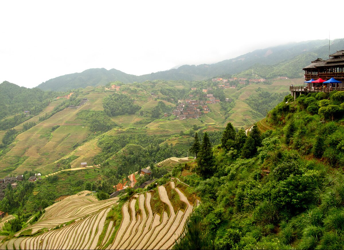
The karst landscape is not easy to live in. The ground is uneven, water often drains quickly through limestone, and flat farmland is limited. Yet for generations, local communities such as the Zhuang and Yao have developed practical and resilient ways to adapt.
One of the best examples is the Longji Rice Terraces. In the narrow valleys and basins between the mountains, people shaped the slopes into terraces and built irrigation systems that channel water across the hillsides. In doing so, they turned difficult terrain into productive farmland and created a remarkable cultural landscape that combines mountains, villages, and agriculture.
Traditional stilted houses show the same logic. Built on steep slopes, these wooden structures are designed to fit the land rather than flatten it. Their raised form also helps reduce dampness and protect against seasonal flooding. Together, these adaptations show how people in karst regions learned not just to survive, but to live well by working with nature rather than against it.
Part 4 审美 · 山水
How Guilin karst shaped China's cultural imagination
Guilin's karst landscape is more than a geological formation. When the Li River reflects rows of limestone peaks and mist moves between the cliffs, the scenery begins to look like a living Chinese ink painting.
For centuries, this landscape has inspired poets, painters, and travelers. It has become a cultural symbol of Chinese ideas about nature, beauty, and harmony. In Guilin, geology and culture are closely connected: the mountains shape the land, but they also shape the imagination.
Guilin karst and Chinese landscape aesthetics
Guilin's karst landscape has long inspired Chinese art. Its misty peaks, shifting outlines, and flowing water closely resemble the visual world of classical Chinese landscape painting.
The Song dynasty artist Mi Fu is known for his "Mi-dot landscape" style, which uses layered ink dots to suggest mountains half-hidden in rain and mist. This technique captures the same soft, atmospheric quality that defines Guilin's scenery. Later, painters such as Huang Gongwang developed similarly spacious and elegant landscape styles that also echo the forms of karst peaks.
Guilin also left a strong mark on Chinese literature. Poets and travel writers praised its rivers and mountains for centuries. In their hands, Guilin became more than a scenic place. It became a cultural symbol — one that represented beauty, reflection, and harmony between people and nature.
The philosophy behind Guilin's landscape
Guilin's karst landscape also helps explain an important idea in Chinese philosophy: harmony with nature. The Li River is soft, curving, and fluid. The limestone peaks are steep, solid, and still. Together, they create a balance between opposites — movement and stillness, softness and strength.
This balance has influenced Chinese aesthetics for centuries. In classical gardens, designers used rocks to suggest mountains and water to suggest rivers. In architecture, buildings were designed to sit naturally within the landscape rather than dominate it. Seen in this way, Guilin's karst scenery is more than a natural wonder. It is also a visual expression of how Chinese culture understands beauty, balance, and the relationship between humans and nature.
Part 5 科学 · 气候档案
The science of karst: what Guilin can teach us about the future
Caves as archives of ancient climate
Guilin's caves are also valuable to science. Stalagmites grow in layers, and those layers can preserve information about past climate conditions, including rainfall, temperature, and monsoon strength. In this sense, a stalagmite works like a natural climate archive.
Sinkholes provide another kind of scientific window. Some are relatively isolated from the outside environment, making them useful places to study species evolution, ecological adaptation, and fragile underground ecosystems.
The Li River basin is also important for karst hydrology. In Guilin, surface rivers and underground water systems are closely connected. Understanding this relationship can help scientists address water management challenges in karst regions.
Part 6 四重价值
Why Guilin karst stands out: four unique advantages
Karst landscapes exist across much of the world, on every continent except Antarctica. But Guilin stands out because it brings together four qualities that few other karst regions combine so well.
Exceptionally pure limestone
One reason Guilin's karst landscape is so distinctive is the quality of its limestone. The region's limestone layers are exceptionally thick and pure, reaching more than 3,000 meters in depth. Because the rock contains few impurities, water can erode it in a relatively even way, producing the graceful limestone peaks for which Guilin is famous.
A perfect blend of peaks and rivers
Another reason Guilin stands out is the way its rivers and limestone peaks come together. The Li River and Yulong River wind through the karst landscape, creating a scene in which peaks rise beside the water and rivers weave through the mountains. This close integration of rock and water gives Guilin a visual harmony that sets it apart from many other karst regions.
A complete karst evolution sequence
Guilin is also valuable because it shows different stages of karst development in one region. Visitors and researchers can find early features such as stone teeth and solution grooves, mature peak forests, and later-stage residual hills. For this reason, Guilin is often described as a living textbook of karst evolution.
A landscape with deep cultural roots
Guilin's scenery is also inseparable from local culture. For generations, ethnic communities such as the Zhuang and Yao have lived among its rivers, peaks, and terraces, developing their own songs, festivals, legends, and ways of life. Traditions such as the legend of Liu Sanjie and the Sanyuesan folk song gatherings give Guilin's landscape a strong human dimension. In Guilin, the scenery is not only natural — it is cultural as well.
Part 7 名实之间
Why Guilin lives up to its famous reputation: science, beauty, and easy travel
Guilin's famous reputation as having "the finest scenery under heaven" is not just about beauty. It reflects a rare combination of science, aesthetics, and accessibility.
Scientifically, Guilin is one of the world's most important examples of humid tropical and subtropical karst. Its peak forests show a clear and well-preserved process of karst evolution, and the wider South China Karst region is listed as a UNESCO World Natural Heritage Site.
Visually, Guilin is exceptional because of the way the Li River winds between steep limestone peaks. The contrast between flowing water and upright stone has made the region one of the classic models of Chinese landscape beauty. The Tang dynasty writer Han Yu captured this image beautifully when he compared the river to a green silk ribbon and the mountains to jade hairpins.
Guilin is also easy to visit. The city has an international airport, good transport links, comfortable river cruises, and many scenic routes that do not require difficult hiking. This makes the landscape accessible to a wide range of travelers, including families and older visitors.
That is why Guilin is more than a beautiful destination. It is a geological landmark, a cultural symbol, and one of China's most visitor-friendly natural wonders.
Plan 出行
Planning your Guilin karst trip: practical tips
| Topic | Details | Tips for international travelers |
|---|---|---|
| Best time | Spring (March–May): misty Li River views — strong ink-painting atmosphere. Autumn (September–November): clearer skies — excellent for photography. Avoid major Chinese holiday peaks (e.g. Labor Day ~May 1–5; National Day Golden Week ~Oct 1–7). | Summer is hot, humid, and rainy; winter can feel damp and cold with limited indoor heating in many places. Spring and autumn are usually most comfortable. |
| International transport | Guilin Liangjiang International Airport (KWL). Direct routes may include Seoul, Bangkok, Kuala Lumpur, Singapore (seasonal). Many travelers connect via Beijing, Shanghai, Guangzhou, Shenzhen, or Hong Kong. | Some nationalities may use 72/144-hour visa-free transit with a confirmed onward ticket to a third country or region — always verify current rules before departure. |
| Regional transport | Airport to downtown: taxi, shuttle, or ride-hailing. Guilin–Yangshuo: Li River cruise (~4 h, highly recommended), high-speed train (~30 min), bus or car (~1.5 h). | Save destinations in Chinese or pinyin; hotel staff can write addresses for drivers. |
| Classic ways to explore | Guilin–Yangshuo cruise; Yulong River bamboo rafting; cycling Ten-Mile Gallery and Yulong River. | Cruise meals are often Chinese/Western buffet; rafting commentary may be limited in English; bicycle rental may require passport registration. |
| Apps & payments | Maps: Amap / Baidu (Google Maps is often unreliable). Payments: Alipay / WeChat Pay with international cards where supported. | Carry some RMB cash for rural shops; download translation apps with offline Chinese. |
| Food & water | Guilin rice noodles; Yangshuo beer fish. | Request less spice if needed; prefer bottled water over tap. |
FAQ
Frequently asked questions
Q: Do I need to be very fit to visit Guilin's caves?
A: No. Popular caves such as Reed Flute Cave and Silver Cave have paved paths and lighting; visits typically take 40–60 minutes without strenuous climbing. For wheelchair access, contact the cave or your hotel in advance.
Q: As a foreign passport holder, do I need a special visa or permit to visit Guilin?
A: Most visitors need a Chinese tourist (L) visa. Eligible travelers may use 72/144-hour transit without visa policies — policies change, so confirm with your embassy, airline, and official immigration sources.
Q: Can I travel smoothly if I don't speak Chinese?
A: Airports, stations, and major sights often have English signage, but daily situations may still be difficult. Download translation apps, keep your hotel address in Chinese, and use ride-hailing apps where available.
Q: Is Guilin physically demanding for older travelers or bad knees?
A: The Li River cruise is mostly seated. Ten-Mile Gallery routes are relatively flat. Xianggong Mountain has steep steps (~15 minutes); Longji has many stairs — plan accordingly.
Q: When is the most beautiful season? Will rain ruin the trip?
A: Rain and mist often enhance the ink-wash mood. Autumn tends to be clearest for sharp peaks. Heavy monsoon periods can occasionally suspend cruises — check forecasts; June flood risk is worth monitoring.
Q: Is Western food available?
A: Yes — especially in Yangshuo's West Street area. Guilin city hotels and cafés also offer international options.
References
- Xuexi Qiangguo. Guilin Karst: A Natural Heritage and a Treasure of Humanity. article.xuexi.cn
- Academy of Chinese Culture. Is Guilin, Guangxi Also a Karst Landscape? chiculture.org.hk
- China Science Communication. "Guilin Karst" Selected into the Second Batch of 100 IUGS Geological Heritage Sites. kepu.gov.cn
- Gong Ke. Evaluation and Development Strategy Management of Ecotourism Resources in Guilin Karst Area. PhD dissertation, China University of Geosciences, Beijing, 2012. CNKI
- Wei Yuelong et al. Characteristics and Formation Evolution of Karst Landscapes in Guangxi. Guangxi Sciences, 25(5), 2018, pp. 465–504. gxkx.ijournal.cn
- Wei Yanlan, Li Wenli, Wang Li. Guilin Karst Landforms and Geological Processes. China Mining Magazine, 2022, 31(S2), pp. 208–209, 216. chinaminingmagazine.com